E(stienne) Jouy
Sixième Jeu de Cartes Géographiques, 1806
Lille and Paris: Chez Vanackere and Chez H. Nicolle
254
Further images
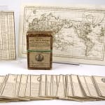
Set of forty-eight cards, with instruction sheet and map. Each card is numbered, and features an emblematic national or regional figure in a rondel at the top. The instructions describe...
Set of forty-eight cards, with instruction sheet and map. Each card is numbered, and features an emblematic national or regional figure in a rondel at the top. The instructions describe the game as largely focused on geographical learning through rote memorization, chiefly of 1) in what part of the world the nation or region is located; 2) what is its capital; and 3) the ability to point to the location on a map. The verso of the instructions tabulates the correct answers, down to latitudes and longitudes. The detailed information on the cards, paired with the careful exactitude of the accompanying map, communicate to the young French learner both the places of others and also the place of the French within the global taxonomy. This sort of identitarian program suits the moment; the colonial enterprise had kicked up its urgency during Napoleon's reign. Cards held in slipcase covered with marbled paper and with paper label. Some rubbing to both card corners and box edges, else near fine and quite scarce, with only three copies in instutional holdings worldwide.


